Airports worldwide are increasingly exposed to drone-related disruptions, posing safety, security, and operational challenges.
In 2024, drones were involved in almost two-thirds of reported near midair collisions at the 30 busiest US airports. In 2025, drone activity caused closures and disrupted flights at major European airports like Copenhagen, Munich, Berlin, and Brussels. In early 2026, a drone sighting suspended operations at Amritsar Airport in India.
Drone detection at airports is no longer optional — it is a fundamental requirement for safe and resilient airport operations.
This article sets out six essential steps to help airport security teams build an effective, scalable drone detection and counter-Unmanned Aircraft System (UAS) strategy.
What is a counter-UAS strategy?
A counter-UAS (Unmanned Aircraft System) strategy is a structured combination of regulatory, technical, and operational measures designed to detect, identify, classify, and — where necessary — neutralise unauthorised drone activity within or near protected airspace.
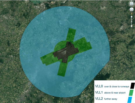
Step 1. Establish a geozone to protect airport airspace security
The first step in any airport counter-UAS strategy is to protect the airport’s airspace through a dedicated geozone. What is a geozone? According to EU Regulation 2019/947, member states can create geographic zones where drone operations are restricted, prohibited, or subject to specific conditions such as height limits, time restrictions, or mandatory equipment like Remote ID. These zones exist to manage safety, security, privacy and environmental concerns.
Airports can opt for two types of geozone models:
Option 1: No-fly zone
A strict prohibition on all drone operations except state flights.
While effective, this approach rules out valuable, controlled drone use cases such as perimeter inspections, wildlife management and infrastructure monitoring, both within and beyond the airport perimeter.
Option 2. Controlled zone with flight authorisation (Recommended)
A geozone requiring drone operators to obtain flight authorisation.
This balances airspace protection with the ability to support beneficial drone operations. Italigns with international best practices and future-oriented airspace management concepts, as it integrates with digital authorisation workflows, Remote ID requirements, and evolving traffic management frameworks such as U-space and UTM.
A comparable approach exists in the United States, where the Federal Aviation Administration (FAA) requires prior authorisation for drone flights in controlled airspace around airports via the Low Altitude Authorization and Notification Capability (LAANC), a digital system providing near-real-time access to airspace permissions.
Explore ACI World’s resources on airport safety and security at store.aci.aero or browse the Safety and Operations category on ACI World Insights Blog.
Step 2. Connect your geozone to a UAS Traffic Management system
A UAS Traffic Management (UTM) system provides a structured way to manage drone authorisations within the geozone. It allows drone operators to submit information the aircraft, pilot, flight path, timing, altitude, and purpose and request a flight autorisation.
What is UTM in the context of airports?
According to ICAO, the aim of UTM is the safe, economical and efficient management of UAS operations through the provision of facilities and a seamless set of services in collaboration with all parties and involving airborne and ground-based functions. A UTM system enables drone operators to submit authorisation requests detailing the aircraft, pilot credentials, planned flight path, timing, altitude, and operational purpose. For airport operators, the benefit is clear: UTM creates a verifiable record of every authorised drone operation, making it straightforward to identify — and act on — any drone that has not been approved.
Implementing UTM allows to distinguish between authorised and unauthorised drone operations.

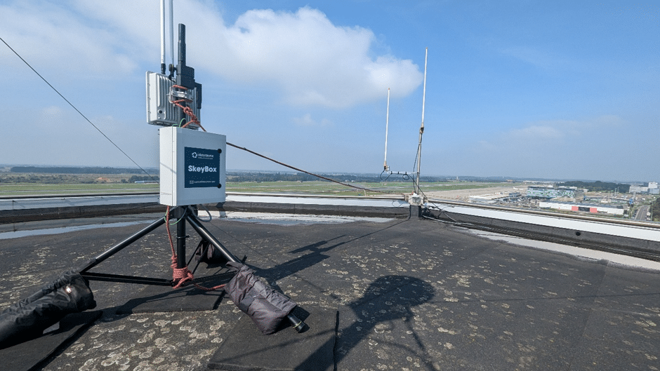
Step 3. Deploy a drone detection system
Hardware: RF Sensors as the foundation
The first practical starting point in building drone detection capability at the airport is a Radio Frequency (RF) sensor deployment.
RF sensors form the backbone of most modern counter-UAS strategies because they offer a cost-effective, non-intrusive, and highly scalable solution.
The number of RF sensors depends on the airport’s size and layout. Smaller airports may require only one strategically placed sensor, while larger hubs benefit from a network of sensors to cover critical zones such as runways, taxiways, and approach paths.
How RF detection works?
RF detectors scan the radio spectrum for signals exchanged between a drone and its controller.
Most drones rely on RF communication for navigation, telemetry, and video streaming, making this method highly effective. RF detection is passive, meaning it does not emit signals, interfere with other systems, or require additional regulatory permissions. This makes RF an ideal entry point for airports starting their drone detection journey.
RF detection focuses on communication signatures rather than visual or physical characteristics. This can reduce false alarms triggered by birds, balloons, or other airborne objects. RF sensors can also cover large areas beyond visual line of sight, offering superior range compared to other systems at a fraction of the cost.
Software
Hardware alone cannot deliver full situational awareness. A software platform that integrates detection, visualization, and analysis is required to transform raw RF signals into actionable intelligence.
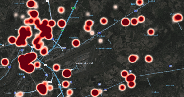
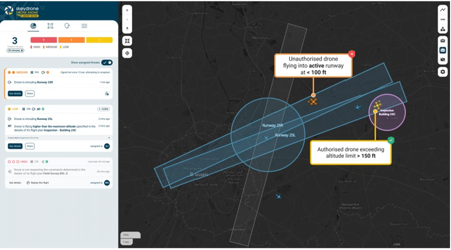
Real-time monitoring provides a live operational view, displaying detected drones and their associated data, such as location, pilot position, drone type, and authorisation status. This real-time visibility enables airport security teams to respond quickly and confidently.
Historical data analysis is equally important. In the initial phase, the focus should go beyond real-time monitoring to uncover deeper insights from accumulated information. By examining trends over time, airports can identify recurring patterns, pinpoint activity hotspots, and detect seasonal trends in drone operations. These insights provide the foundation for understanding the airport’s true exposure to drone activity and inform the development of appropriate risk mitigation measures.
The true power of RF detection comes when it is integrated with the UTM. By linking detected drones with flight authorisation records, the software can instantly distinguish between authorised and unauthorised operations. This reduces false alarms and ensures that response resources are focused on genuine threats.
Building a CONOPS (Concept of Operations)
Once sufficient data has been collected and analysed, airports should perform a safety risk security threat assessment. This includes creating a detailed CONOPS – a structured document specifying how each category of drone detection should be handled. The CONOPS describes when a detection warrants monitoring, when it demands escalation, and when it should trigger a coordinated operational response. This provides structure and clarity for all stakeholders involved in managing drone-related risks.
Step 4. Refine drone threat assessment
Detecting a drone is only the beginning. Not every drone that enters a geozone poses an immediate threat. A sophisticated threat assessment strategy ensures that alerts are meaningful and operational responses are proportionate.
Define what constitutes a threat
The real-time detection platform should be configured to apply operational logic that accounts for the airport’s specific environment. A drone may only be classified as a threat when it is simultaneously unauthorised and operating within pre-defined geographical zones that present a risk to runway operations or critical infrastructure. These zones should be carefully defined based on runway configuration, approach paths, safety buffers, and airport-specific risk tolerances.
Step 5. Extend to a multi-layered hardware network
RF detection is an excellent starting point, but it has a limitation: while RF sensors effectively identify drones using traditional radio links, they cannot detect drones controlled via cellular networks (4G/5G) or fiber connections, which malicious actors increasingly exploit to bypass conventional detection methods.
To achieve comprehensive coverage, airports can adopt a multi-layered detection strategy that combines complementary technologies:
| Technology | Capability |
|---|---|
| RF sensors | Detects drone-controller radio communication |
| Radar systems | Provide precise range measurements, detecting drones regardless of their communication method. |
| Electro-optical/infrared (EO/IR) | Deliver visual confirmation, essential for positive identification and forensic evidence. |
| Acoustic sensors | Detect drones based on sound signatures, useful in environments where RF or radar coverage is limited. |
Each layer addresses a different vulnerability, creating a resilient detection architecture capable of handling both careless hobbyists and criminal operators. RF remains the foundation due to its affordability and ease of deployment, but layering ensures the airport is prepared for evolving threats.
A multi-layered counter-UAS detection architecture combining different types of detection hardware for comprehensive airport airspace coverage. Credit: SkeyDrone
Step 6. Assess counter-drone capabilities
Once an airport has a mature detection and threat assessment in place, it can evaluate the use of effectors – technologies designed to interrupt, disable, or remove a drone once it has been identified as a threat. Understanding the different types of effectors and their implications is critical before deploying such a system.
Kinetic effectors
Kinetic effectors neutralise drones through physical means. They may intercept the drone directly or destroy it through impact or energy. Kinetic effectors include:
- Net guns that entangle and ground the drone
- Anti-drone shotguns
- Interceptor drones designed to capture or collide with the target
- Laser systems that inflict thermal damage
Non-kinetic effectors
Non-kinetic effectors disrupt a drone without physical contact. They target drone’s communication, navigation, or onboard electronics. Examples of non-kinetic effectors:
- RF and GPS jamming
- Spoofing systems that feed false navigation signals
- Electromagnetic pulse (EMP) devices that can disable electronic components
Although these systems can be highly effective, they come with significant risks. Kinetic effectors may cause debris to fall in sensitive areas, while non-kinetic effectors can unintentionally interfere with legitimate communication or navigation services, including those used in aviation.
Effector deployment must be approached cautiously.
Conclusion
Implementing drone detection at an airport is a phased, strategic journey that combines technology, procedures, and collaboration.
The six steps outlined here form a logical progression:
Starting with geozone creation and UTM integration establishes a regulatory framework that enables safe, authorised drone operations. Deploying RF sensors provides an affordable and effective foundation for detection, delivering real-time visibility and actionable intelligence. As data accumulates, airports can refine threat criteria, integrate response protocols, and build a CONOPS that aligns aligns with Air Traffic Control (ATC), Security Operations Centre (SOC) and Airport Operations Centre (APOC) workflows.
For airports seeking comprehensive protection, a multi-layered detection strategy that combines RF, radar, optical, and acoustic technologies offers the robustness needed to counter both careless pilots and sophisticated adversaries. Finally, selecting and deploying effectors must be approached with caution, ensuring legal compliance and operational safety and security.
Key takeaways
- Drone incursions are a global operational risk: In 2024, drones were involved in nearly two-thirds of near-midair collisions at the 30 busiest US airports, and major European airports experienced drone-related closures in 2025.
- Geozoning is the essential first step: Designating a controlled, authorisation-based geozone — aligned with EU Regulation 2019/947 or the FAA’s LAANC framework — creates the legal and operational foundation for everything that follows.
- UTM integration separates authorised from unauthorised drones: Without a linked UAS Traffic Management system, detection data alone cannot determine whether a drone is a legitimate operation or a threat.
- RF sensing is the most cost-effective detection foundation: Passive, wide-area, low-false-alarm, and scalable — RF sensors are the right starting point for airports at any stage of counter-UAS maturity.
- Effectors require legal authorisation before deployment: Both kinetic and non-kinetic counter-drone tools carry significant safety and regulatory risks; their deployment must be coordinated with national aviation authorities and law enforcement.


comments